As big mapping corporations substitute public institutions in curating spatial data, informal residents' voices are still yet to be acknowledged.
Sunday, July 23rd of 2017, a 22-year-old Uber driver Guilherme e Silva Maia was waiting for a passenger at Ancuri, a peripheral neighbourhood of Fortaleza, when two unknown assailants shot and killed him. Authorities claimed that the murderers had mistaken him for a member of their rival gang, as his car’s dark windows were closed, disobeying informal rules printed on the walls upon entering the neighbourhood: “Remove helmet. Lower car windows. Turn on light inside the car”. Three years later, on October 21st of 2020, a group of drug dealers shot Christiano Coimbra, an O Globo newspaper employee, after having entered the community of Cidade Alta, following a transit app suggestion to bypass traffic on Avenida Brasil, a major artery of Rio de Janeiro.
Episodes like these tend to reignite discussion about the need for an “avoid dangerous areas” feature on these apps, which is reportedly available on Waze for some cities in Brazil. On Waze, these areas are supposed to be collaboratively marked, just as with the other alerts in the app. But in the future, this task might fall to an algorithm, with no guarantee that, through machine learning, it won’t simply label informal settlements as violent spaces. Handing over the control of marking potentially violent areas to new stakeholders (such as Uber or Waze) without the moderation of democratic state institutions represents a major shift in the territorial governance of cities in the Global South. This shift may end up substituting the pursuit of a good, inclusive, public mapping system, for one governed at the whim of corporate interests, whose agenda is not often convergent with those of vulnerable residents of informal settlements. And by “good, inclusive, public mapping”, we mean a system that is attentive to the voices of the residents of the most vulnerable neighbourhoods, capable of supporting a democratic urban decision-making process.

WILSON MEDEIROS, DIÁRIO DO NORDESTE NEWSPAPER, FORTALEZA, 2013.
The cases of Silva Maia and Coimbra underline the importance of identifying who controls and moderates spatial information. Algorithms act according to what they are trained for, and human beings are the ones training them. Therefore, when algorithms are clearly reinforcing existing inequalities, it is crucial to question who writes these algorithms, and in whose interests they are writing them. More importantly, these people should be held accountable for the socio-spatial effects of their products.
The last decade has seen a great proliferation of digital georeferencing tools based on urban mapping algorithms: from spatial data banks such as Google Maps and Bing to location collection functionality on social media apps such as Whatsapp and Twitter. This might constitute an opportunity for boosting democratic decision-making in the urbanisation process, as the technology enables people without technical training to share maps tailored to their needs. However, this is a two-way street: citizens map but are also being mapped. A person’s location data is a valuable resource, which has been commercialised largely under the noses of both individual citizens and their representative democratic institutions.
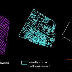
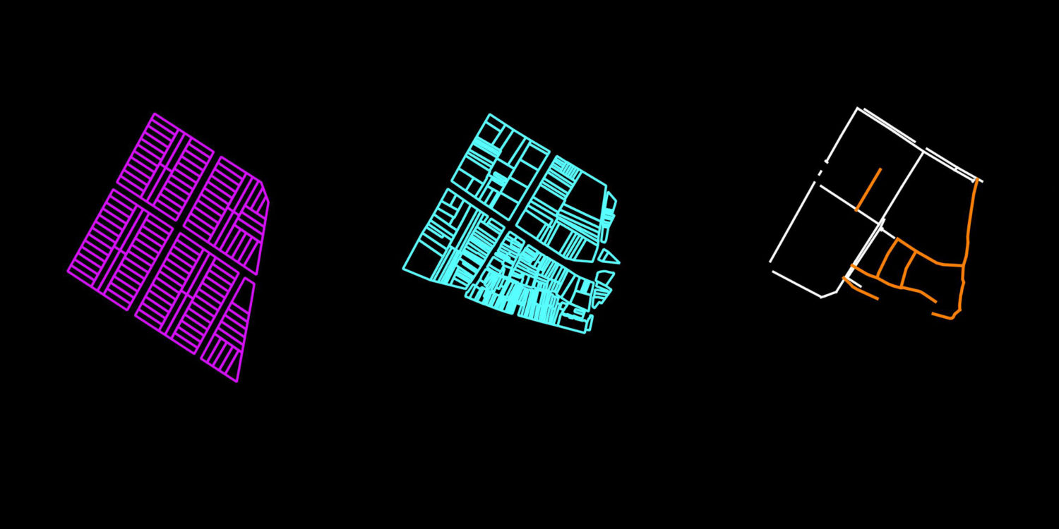
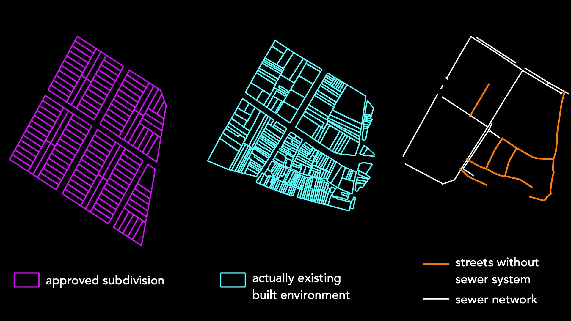
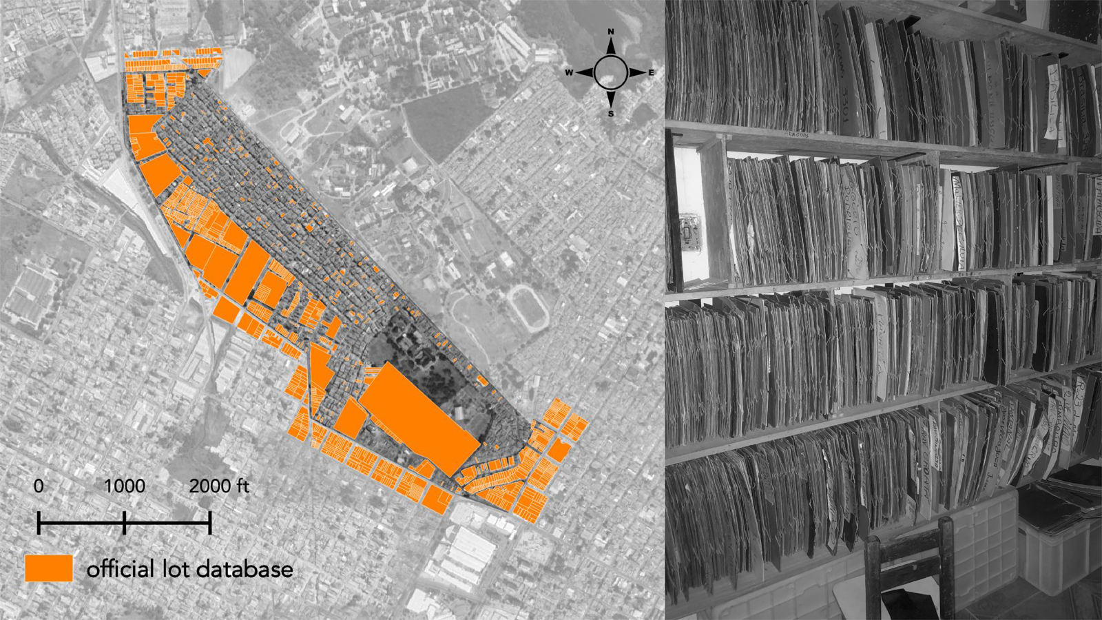
For decades mapping was an expensive, time-consuming and hand-made process. Therefore, in the cartographic field, power was concentrated in the hands of a few people, from colonisers in the early centuries to, more recently, technicians usually hired by the state. Before the popularisation of Information and Communication Technologies (ICTs) and Geographic Information Systems (GIS), residents of the unmapped spaces did not officially exist, as they were absent from planning agencies’ databases. At the end of the day, this absence denied them certain opportunities afforded to those with the status of full citizenship: including government investment in their neighbourhoods and welfare. The image below from the community of Lauro Vieira Chaves illustrates a typical situation of major metropolises in the Northeast of Brazil where the subdivision design proposal approved by local planning agencies differed from the actually existing built environment. Here, urban development had occurred informally, bypassing existing land use control mechanisms because they presupposed plot sizes and streets much larger and wider than an average urban dweller could afford. Public utility companies would often deny services to settlements that did not conform to these plot sizes, on the grounds that they were illegal, and, in any case, dismissing them as exceptional cases. As such, in the same image, we see that the network of sewer systems does not cover the informally opened streets.
As well as exposing these inconsistencies, the popularisation of satellite image databases has also revealed the extent to which municipal data derived from formal urban development is incomplete. Public mapping of Brazilian cities, for example, is extremely inadequate: partly due to the huge number of informally developed settlements, which pose additional difficulties in identifying the basic urban elements, such as streets, plots, and building footprint; and partly because the main driver for local government to update public maps is the increase in tax collection it entails, yet when it comes to informal areas this does not hold true, since most of their residents are below the minimum income threshold to pay property taxes.
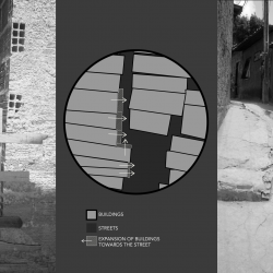
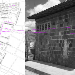
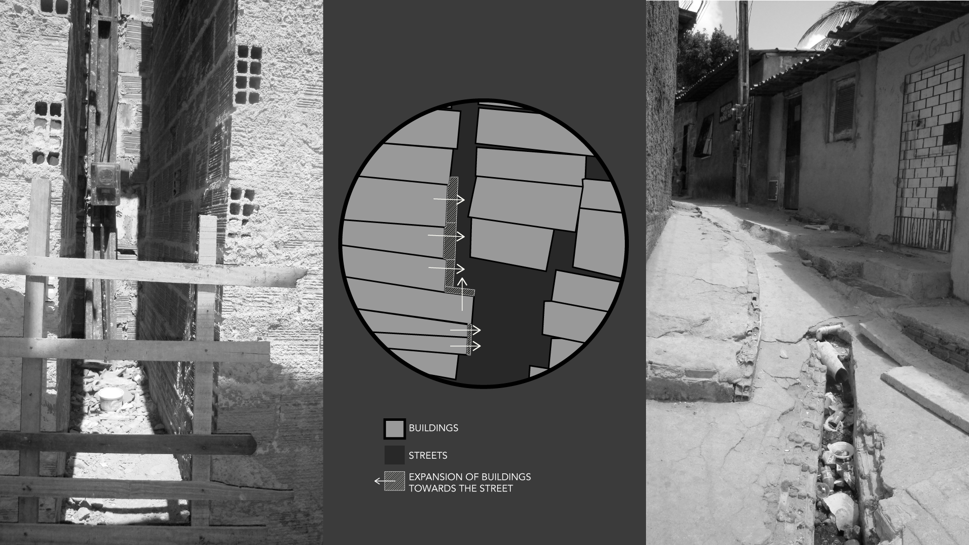
There are several issues that further complicate the everyday urban experience for residents of unmapped spaces. One of the most acute problems is the blurred boundary between public and private space. Without clearly established development rules, families keep expanding their houses. While construction flexibility is an asset, the lack of agreed-upon spatial limits produces overexpansion of buildings toward sidewalks, streets, and alleys, making public circulation harder and generally degrading the built environment. Residents of informal settlements often ask which government agency is responsible for the land use control, and to whom they should report events like a neighbour interrupting their street or cutting access to their house. Yet, if it’s not formally established where public space should be, it is impossible to claim that someone appropriated it, as we can see in the photos below from the community of Lagamar. Even though these settlements have seen an increase in legitimacy in recent years and have gained access to some basic urban services, they lack structured spatial governance, one of the basic elements of which being a map accurately depicting the existing built environment.
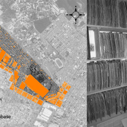
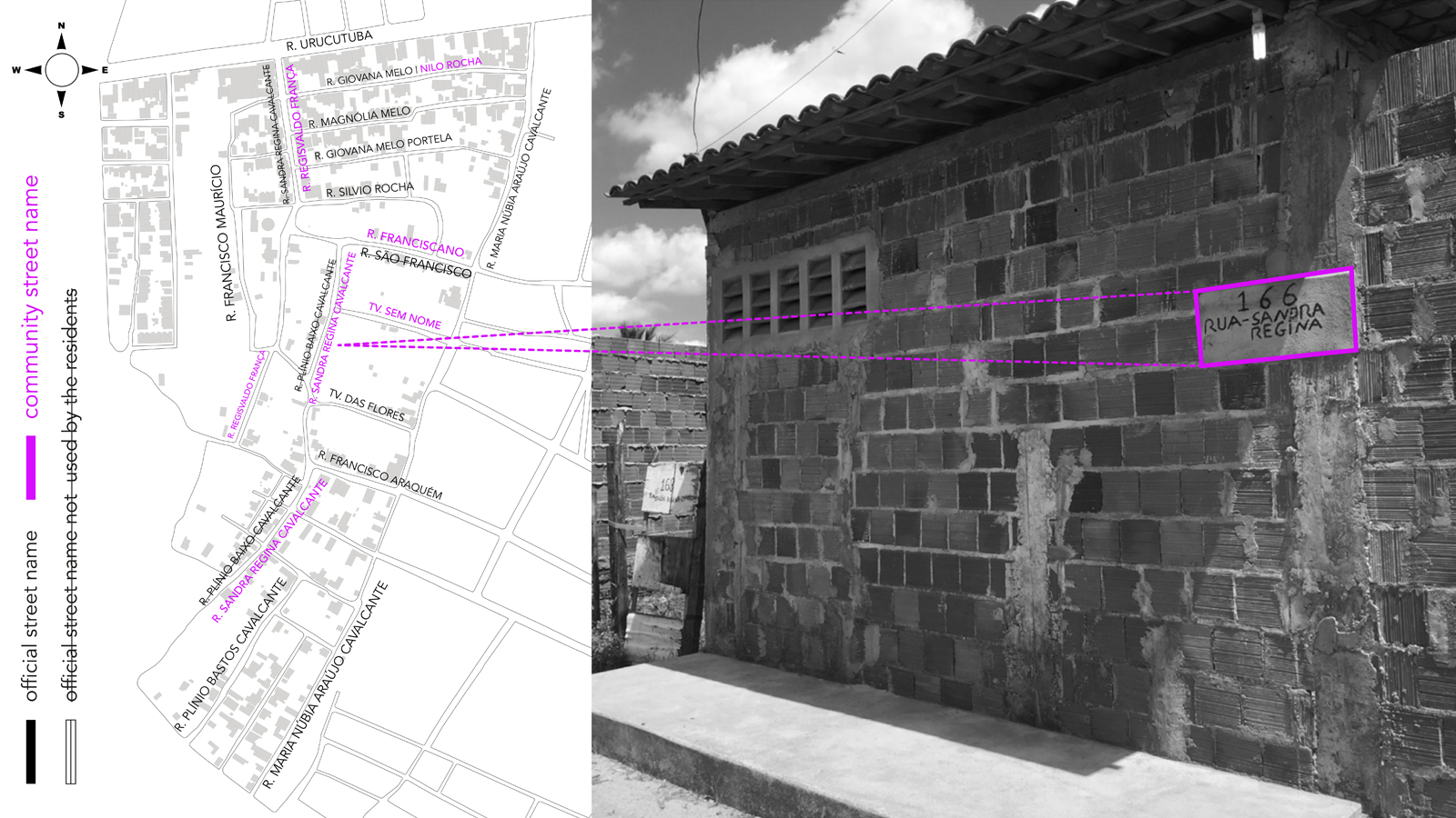
Another dimension of inadequate mapping for informal residents relates to the inconsistency of street address databases. It is not difficult to find cases where citizens have limited access to public services because their addresses are not easily recognised. In Fortaleza, Brazil, according to a local newspaper, more than 70% of existing streets in 2019 were not official, meaning that their names were not legally recognised by the local government (see for example the community of Marrocos). This discrepancy may result in a lack of access to public health facilities for residents whose reported address is not within the service radius. Similarly, coronavirus data was not georeferenced in thousands of cases in Fortaleza’s informal settlements, making it impossible to prevent, monitor and control the spread of the virus.
From a public interest perspective, it seems nonsense to perpetuate the current scenario of poor spatial governance. Yet, local administrators have incentives for undercounting and underreporting the demands of low-income residents informal residents because this inefficiency allows them to disguise their lack of effort to provide adequate services in these areas.
As local governments have failed to build a good spatial data infrastructure for informal settlements, other stakeholders are stepping in. The possible consequences of allowing corporations to decide what goes “on the map” were recently illustrated in the award-winning Brazilian film Bacurau (2019). Set in a not too distant future, the film tells the story of a village located in the impoverished Northeast of Brazil. The village simply disappears from Google Maps and, shortly afterwards, some of its residents are mysteriously murdered. In the story, the fact that the village is no longer on the digital map symbolises its irrelevance, and it is this that ultimately allows the murders to go unnoticed. While this is fiction, it is not too far off from the real threat posed by algorithms (moderated by big tech corporations) deciding the boundaries of “crime-prone neighbourhoods”.
Since the popularisation of GIS services in the mid-2000s, private companies have become more efficient in producing and disseminating spatial data than municipal administrations. As a result, important public services in Fortaleza such as health facilities have been registering patients’ addresses according to Google Maps. Public schools, several social services, and even urban management agencies are choosing to work with Google satellite image and address databases, because they more closely correspond to the existing built environment than the official data. The local transportation planning department claims their data on mobility patterns is outdated, and, even though Uber is allowed to operate in the city, the municipal government has no access to its database on population mobility patterns. Due to the inconsistencies of transport agency data, the state government resorted to private telecommunication companies’ data on georeferenced mobile service usage in order to monitor population compliance with COVID-19 lockdown measures.
Currently, there are two competing narratives surrounding informal settlements: conservatives describe them as inevitably filthy hotbeds of crime and urban blight, home to undeserving citizens; the creative class, meanwhile, depicts them as centres of alternative urban life, full of possibilities, opportunities, and self-made entrepreneurs. Residents have no mechanism to control either of these oversimplified accounts of their reality. Whether or not these narratives are informed by state or corporate stakeholders, the most important perspectives continue to be ignored.
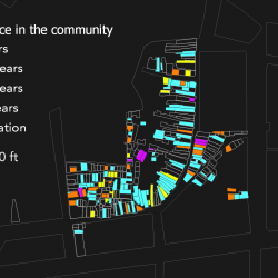
During the development of the masterplans for three informal settlements in Fortaleza, the authors encountered some encouraging community attempts to control the narrative about their territory. In one of these settlements, Poço da Draga, a group of residents had previously conducted a community census of each household, much more accurate than official censuses. For them, this initiative would confer greater tenure security and enhance their ability to question redevelopment proposals of their neighbourhood which had not considered their spatial demands. The initiative is also a consequence of what the residents saw as a condescending attitude of distrust that manifested in the official data, which they felt stigmatised them by highlighting their social problems: insufficient education, high crime rates, and poor housing conditions. Data collected by the community revealed much greater levels of employment and university education than was reported by public agencies.
In Pici, another informal settlement, a residents’ association had kept a communitarian land registry service recording who owns each plot of land. Every time a resident sold a plot to another family, they would inform the association who would charge a small fee to file the transfer agreement and the I.D. of the new owner. While this seems a very insecure and precarious system, the initiative functioned as an efficient social control mechanism, intended to confer legitimacy to the owners, particularly important in a place where municipal records do not include even the street names and addresses.
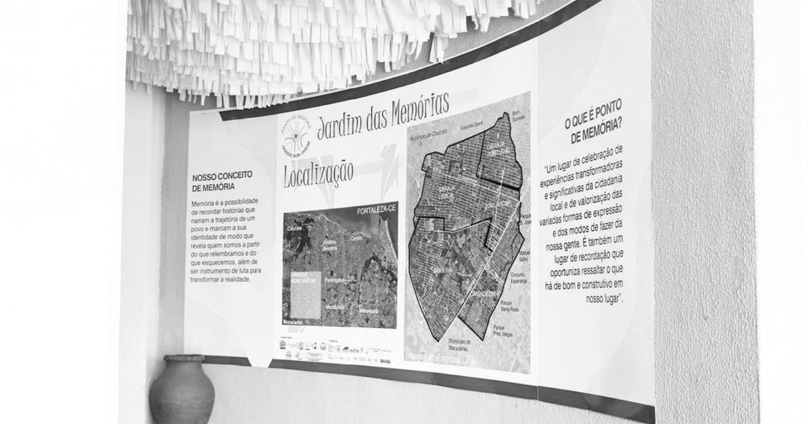
In Bom Jardim, an initiative of social memory and community archiving stood out. It collected oral reports of the community’s history, but also made use of maps to tell, for example, the history of informal occupations in the area. The stories speak to the residents’ great desire to combat the stigma that their neighbourhoods are violent, lawless and inhabited by unscrupulous profiteers, and replacing it with reports of their history and their potential. These moves also manifest the residents’ worries about not being able to make visible their collective urban problems (such as inadequate services). Spatial data production and dissemination is a key part of their strategy to control the dominant narrative.
IGOR GRAZIANNO
In all three initiatives, residents respond to what they perceive as gaps in the dominant mode of mapping. In Poço da Draga, official mapping of census data has been used to capture the community’s precarities through negative socio-economic indicators, which contribute to stigmatising them. A similar gap was perceived by residents of Bom Jardim, who were also afraid that their shared memory of occupying the land and resisting eviction would be lost by the prevailing narrative of the neighbourhood. In Pici, residents felt the necessity to control use of their shared spaces, as public planning agencies do not have any information on who owns each plot of land.
Some of these experiences would not have been possible without the recent development and popularisation of GIS digital tools, and social media is a potential ally to echo informal residents’ accounts of their urban reality. Yet, these experiences can hardly influence public opinion, remaining localised and intermittent experiments. The ubiquity of big tech products offers no institutional mechanism to prevent the rise of other, even more harmful, stakeholders. The monopolistic nature of the tech industry, coupled with the state’s inability to regulate these transnational companies, ensures that these powerful players enjoy a severe lack of accountability.
While there is a clear need for producing and updating spatial data on urban mobility, land property, housing conditions, and several other urban services on informal settlements, Google Maps’ emphasis, for example, points toward mapping local businesses. This tends to picture residents of informal settlements as either consumers or service providers for untapped markets (especially for the platform economy), rather than citizens who deserve to have their rights respected. Assigning some of these spaces as “dangerous areas” should raise a yellow flag to the consequences of privatised mapping selectively recording what is going on in these spaces.
Informality and inaccurate data go hand in hand. Substituting the inadequate mapping of democratically elected governments for the self-interested mapping of profit-seeking tech companies will not help residents of informal settlements in their quest for spatial inclusion. On the contrary, despite resident’s use of digital spatial tools to inform the dominant spatial narrative about their territory, they are not powerful enough to fight the structural uneven development trends that neglect their needs. In the end, despite all technological progress, governance of these environments has remained unresponsive to residents’ needs.
Cities After Algorithms
Cities After Algorithms is a content series exploring how algorithms generate and influence the spaces we live, work and move around in. Algorithms shape the city after their own image, but it is an image they have been trained to see. The tendency to mistake collected data for reality produces a self-fulfilling prophecy by leaving little room for intervention, experimentation or otherness. The more this technological determinism rules the use and design of cities, the more the city will be organised after mechanical parameters instead of socio-political ideals. The special series Cities After Algorithms is produced in collaboration with Failed Architecture, and is supported by the Dutch Creative Industries Fund.
MARIANA COSTA-LIMA
Mariana is an architect and a professor of urban planning from Brazil. She holds an MA in Architecture from Universidade Federal do Ceará and her research interests focus on the production and analysis of spatial data, especially in informal settlements.
CLARISSA FREITAS
Clarissa is a Professor of Urban Planning in Northeast Brazil. She conducts community action research in informal settlements and produces data to that end. #RTTC #insurgentplanning
SARAH FARIAS
Sarah is a Brazilian architect who explores the potentialities and challenges of building knowledge about the city using spatial data, participatory mapping and Geographical Information System (GIS).